Comprehensive Assessment of Satellite Visibility and Positioning Accuracy in Benghazi: A 24-Hour GNSS Evaluation in the Al-Salmani Al-Gharbi Region
Keywords:
GNSS, Satellite Visibility, GPS, Galileo, Dilution of Precision, Satellite SystemsAbstract
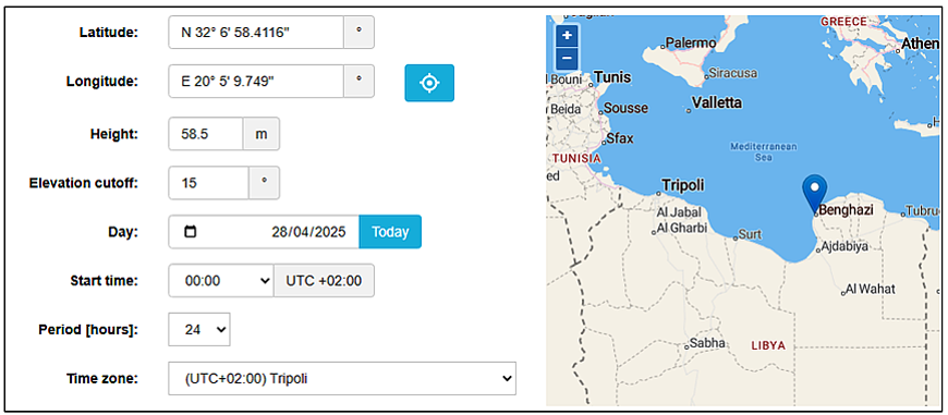
Using the Trimble Online GNSS Planning Tool, a comprehensive analysis was conducted to evaluate the satellite visibility and positioning accuracy in the city of Benghazi, specifically in the Al-Salmani Al-Gharbi area. The study was structured around a 24-hour period, spanning from 12 AM to 11:59 PM Libyan time. This timeframe was selected to assess the satellite availability and the corresponding Dilution of Precision (DOP) values for both GPS and Galileo satellite systems, which are crucial for accurate navigation and positioning. Initially, the analysis focused on the GPS satellites. Upon selecting the geographical coordinates for the specified location, a total of 32 GPS satellites were identified as available within the observed timeframe. Each satellite exhibited varying visibility durations, influenced by its elevation angle, which is a critical parameter in GNSS applications. The elevation angle of satellites is pivotal since higher angles generally provide more reliable signals, leading to improved accuracy in positioning. During this evaluation, it was observed that the number of visible GPS satellites fluctuated between 6 and 11 at different times throughout the day. Following the assessment of GPS satellites, a similar process was executed for the Galileo satellite system. The analysis revealed that there were 29 Galileo satellites available within the same 24-hour period. The visibility of these satellites also varied, with the number of satellites observed ranging from 5 to 10. The monitoring of DOP values during this period was essential, as it provides insight into the potential accuracy of the positioning solutions derived from satellite signals. To gain a more comprehensive understanding of the satellite availability, both GPS and Galileo satellites were considered simultaneously. This combined analysis resulted in a total of 61 satellites being available. Notably, the monitoring revealed that the maximum number of satellites visible at any given time reached 18. This figure exceeds the satellite counts observed when each system was evaluated individually, showcasing the benefits of utilizing both satellite systems together. The increase in the number of simultaneously visible satellites is particularly advantageous for navigation and tracking applications. A higher satellite count typically leads to lower positioning errors, as it enhances the geometric configuration of the satellite signals. Consequently, the DOP values calculated during this analysis demonstrated lower readings when both GPS and Galileo satellites were combined, compared to the isolated evaluations of each system. This reduction in DOP values indicates a higher potential accuracy for navigation and location determination, thereby minimizing the error percentage associated with positioning solutions.